
The solution from the skies to save endangered species
Four hundred years ago Galileo created a revolution by pointing his telescope to the skies. Now an astrophysicist and an ecologist from Liverpool John Moores University are reversing this perspective to help endangered species including rhinos and orang-utans. The world’s first astrophysics-ecology drone project, could be the answer to many global conservation efforts.
The authors of the study, published in the International Journal of remote Sensing, have brought together their expertise using drones, thermal cameras and the techniques used to analyse objects in space to find a solution to this 21st Century challenge for Earth.
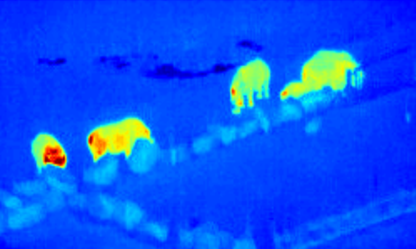
They are using software that astronomers have developed to detect very distant objects in space, but on conservation drone footage. The paper shows that this software can robustly pick out the heat signatures of animals in an automated way. Identifying animals in such data is usually done “by eye” by individual researchers, which is very time-intensive given the exponentially growing volumes of footage. The hope is that this will overcome a fundamental bottleneck in conservation research.
Professor Serge Wich, from LJMU’s School of Natural Sciences and Psychology and the University of Amsterdam’s Institute for Biodiversity and Ecosystem Dynamics, is a pioneer in using drones for conservation work and is the founder of conservationdrones.org, commented:
“As an ‘eye in the sky’, conservation drones are helping the fight against illegal deforesting, poaching and habitat destruction, all leading to many species being endangered, including rhinos, orang-utans, and elephants. Now, teamed with the same astrophysics analysis techniques used to find and identify objects in the far-distant Universe, we can try to do this more efficiently.”
“The World Bank estimates that ecosystems provide $33 trillion every year to the global economy and biodiversity loss and consequent ecosystem collapse is one of the ten foremost dangers facing humanity. We hope this research will help tackle these problems by allowing anyone in the world to upload their aerial data and in real time get back geo-locations of anything, whether that be survivors of natural disasters, or poachers approaching endangered species, or even the size, weight and health of livestock.”
Dr Steve Longmore, from the LJMU Astrophysics Research Institute, explains why this is possible:
“Astrophysicists have been using thermal cameras for many decades. Crucially, it turns out the techniques we’ve developed to find and characterise the faintest objects in the Universe are exactly those needed to find and identify objects in thermal images taken with drones. The key to success is building libraries of the thermal heat profiles that act like “thermal finger prints”, allowing us to uniquely identify any animals detected. Our goal is to build the definitive finger print libraries and automated pipeline that all future efforts will rely upon.”
The next stage of this research, which will be funded by the Science and Technology Facilities Council (STFC), is to start expanding these techniques to other equally significant applications, including disaster relief and search and rescue.
This new drone technology is part of the growing technological innovation within LJMU. The Astrophysics Research Institute is also developing the world’s largest fully robotic telescope, a scaled up version of the Liverpool Telescope, located at the Roque de Los Muchachos Observatory, on the island of La Palma, and operated by LJMU as a national facility.
Video and ImageCredits: Serge Wich, Andy Goodwin (Remoteinsights), James Crampton, Maisie Rashman, Maria de Juan Ovelar, Steven Longmore. LJMU and the Knowsley Safari Park

